Offwell Wetland Survey
Ecological Survey Methods
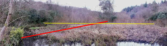
The Wetland at Offwell in winter, looking North
from the dam wall.
The red line is the north/south transect. The yellow line is the east/west
transect.
Note: The surveys were carried out in the summer.
| The main ecological survey of the wetland took the
form of two transects through the
wetland. The line of these is shown in the panorama above. The red line represents the
North/South transect (North being in the direction of the tall trees at the top of the
image). The yellow line shows the position of the East/West transect. The survey was
carried out in September, in late summer, whereas the panorama above shows the wetland in
winter. At this time most of the vegetation has died back and it therefore allows the
whole wetland to be seen more clearly. . |
| A transect
line, marked at 1 metre intervals, was laid through the wetland from North to South. This
followed the line of the slope from dry land down towards open water. A second transect
was also laid passing from East to West through the wetland and crossing the slope at
right angles. (Diagram here.) In each case the line
passed through dry land, marsh, swamp and open water consecutively. Three different types of line transect were carried out along each of the two lines.
|
 |
| The three line transects carried out were a continuous line transect and two interrupted line transects, with intervals of 1m and then every other metre. The continuous line transects involved noting the height and species of every plant which touched the line along its entire length. The interrupted line transects noted the height and species of only those plants which touched the metre marks, either every metre, or every other metre. The purpose of doing this was to illustrate the difference in the level of data obtained using these slight variations in method, for the benefit of environmental students. |