Offwell Wetland Survey
Transect Survey Methods
(continued)
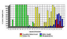
Belt Transects were also carried out along the North/South and East/West transects (panorama). A one metre quadrat was set up every other metre along the lines. The % cover and the maximum height of each plant species inside the quadrats was estimated and measured respectively. The height and thickness of the vegetation in certain areas, as well as the water depth, made it impossible to use a standard frame quadrat. The 1m quadrat had to be measured out each time and marked using bamboo poles as corner markers. If the object of the survey had been purely ecological, that is, to investigate the habitat composition and structure, only the belt transect would have been carried out. This would have provided the required level of data on its own. A continuous line transect alone, would have taken almost as much time to carry out as the belt transect and would have yielded less data (more information here). Surveying takes time and it costs money to employ someone to carry out the survey. Therefore the best method, involving the minimum input of time to produce the desired level of results would be chosen. The variety of sampling methods employed in this survey were aimed at providing educational material, as well as the ecological data. Unfortunately, time did not allow for detailed sampling of the fauna in this survey. However, a partial species list was made for the open water area. General observations were also made on animals seen while conducting the plant survey. A more comprehensive survey of the fauna is planned for the future. |