Offwell Wetland Survey
Why use line transects?
Line transects are used when you wish to illustrate a particular gradient or linear pattern along which communities of plants and, or animals change. They provide a good way of being able to clearly visualise the changes taking place along the line. Depending on how detailed the line transect is, they can usually be accomplished fairly quickly. Line transects do not produce as much information on the relative densities of individual species as a belt transect would do. A line transect tells you what is there, but gives limited information on how much of it is present. If detailed density information is required then a belt transect must be carried out instead.
|
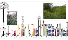 |
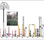
The transect diagram on the left illustrates the type of data which is collected using a continuous line transect . This notes every individual which touches the line. The data is displayed in the form of a diagram, using symbols for different species, which are drawn to scale. This is a useful way of being able to clearly visualise what changes are taking place along the line. It enables patterns of zonation in species along the line to be picked out. The photographs in the left-hand diagram are purely there for illustrative purposes and would not normally be included. |
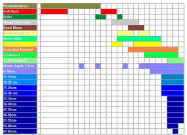
| These patterns of zonation can then be demonstrated more clearly in charts such as the distribution diagram on the right. |
|
Where there is a great deal of plant cover, continuous line transects are useful only over relatively short distances. If there are a great many plants touching the line, it is very time-consuming to survey over long distances. It is also difficult to adequately display the data so that it can be shared with others. This is illustrated by the continuous line transect diagrams drawn for Transect 1 and 2 through the wetland (see the 'Results' link at the foot of the page). The original paper transect diagrams from which these are redrawn required 5 x A4 sheets of graph paper stuck together to order to adequately display the entire length of the transect! However, where individual organisms are sparsely distributed along the line (for example in a desert, or on sand dunes), continuous line transects become workable over longer distances. As continuous line transects note every individual touching the line, they can also become very tedious where separating individuals of a species is a problem. An example of this is plants such as grasses or mosses, which spread through vegetative growth. Where does one plant stop and another begin? This does not just apply to grasses and mosses, but to a wide variety of other plants and also some animals. The Yellow Iris and Branched Bur-reed plants involved in the Wetland Survey are another example. More here If a particular area does not suit the continuous line transect method, interrupted line transects may be the answer. These note individuals touching regular points along the line, for example at every metre mark. These can be carried out reasonably quickly over long distances and may allow an area to be surveyed fairly rapidly. Displaying the data collected in line transect diagrams also becomes easier because the horizontal scale can be adjusted to fit smaller sheets of paper. The disadvantage in this case is that many of the species present may be overlooked if the interval selected is too large. To illustrate this, the number of species recorded on each of Line Transects 1 and 2, using three different line transect methods is shown in the table below.
|
| No. of Species Recorded | Line Transect 1 N/S | Line Transect 2 E/W |
Continuous |
29 | 36 |
Every metre |
16 | 19 |
Every other metre |
10 | 12 |
It is important to bear in mind that the type of method which is most suitable will depend entirely on the habitat under investigation and on the purpose of the survey. If an interrupted line transect, with measurements taken at every other metre, had been the sole method of surveying the Offwell Wetland habitat, it would have been less than ideal. However, in a different habitat it might be perfectly acceptable. Survey methods have to be decided on an individual habitat basis. More information on the plus and minus points of the different types of transect, as related to the Wetland Survey, can be found on the individual transect diagrams presented in the results section.
|